Study the map of DAMBO DISTRICT and use it to answer the ...
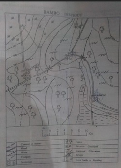
Study the map of DAMBO DISTRICT and use it to answer the question below
The scale of the map in representative fraction (RF) is
1: 200,000
1 : 50,000
1 : 150,000
1 : 10,000
Correct answer is A
No explanation has been provided for this answer.
The major factors which determines the rate of infiltration of water into the sub-soils is? ...
The direction of DAMBO from Hume is------ ...
The movement of people from a village to an irrigation project area may be described as? ...
A well will always contain water if it is dug ...
The climate can be described as ...
Which of the following does not cause coastal erosion? ...
Six's thermometer is used to measure ...
Most of the iron ores produced in Africa are exported because? ...