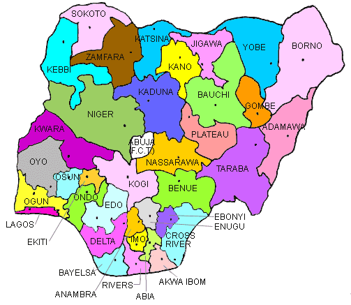
Nigeria, the most populous country in Africa, is a federal republic consisting of 36 states and a Federal Capital Territory (FCT). Each state has its own government structure and operates semi-autonomously under the Nigerian Constitution. Understanding the structure of these states and their capitals is essential for appreciating Nigeria's diversity, culture, and administrative framework.
In this article, you’ll find a complete and updated list of the 36 Nigerian states along with their capitals, categorized for easier reference. Whether you are a student, traveler, researcher, or policy analyst, this list serves as a valuable reference for understanding the geopolitical layout of Nigeria.
🗺️ Nigeria’s Federal Structure
Nigeria operates under a federal system of government, where powers are shared between the central government and the individual states. Each of the 36 states has its own executive, legislature, and judiciary. The Federal Capital Territory (FCT), which houses Abuja, serves as the national capital and is governed by the Federal Government directly.
📍 Complete List of 36 Nigerian States and Their Capitals
Here is the official alphabetical list of all 36 states in Nigeria along with their capital cities:
| S/N | State | Capital |
|---|---|---|
| 1 | Abia | Umuahia |
| 2 | Adamawa | Yola |
| 3 | Akwa Ibom | Uyo |
| 4 | Anambra | Awka |
| 5 | Bauchi | Bauchi |
| 6 | Bayelsa | Yenagoa |
| 7 | Benue | Makurdi |
| 8 | Borno | Maiduguri |
| 9 | Cross River | Calabar |
| 10 | Delta | Asaba |
| 11 | Ebonyi | Abakaliki |
| 12 | Edo | Benin City |
| 13 | Ekiti | Ado-Ekiti |
| 14 | Enugu | Enugu |
| 15 | Gombe | Gombe |
| 16 | Imo | Owerri |
| 17 | Jigawa | Dutse |
| 18 | Kaduna | Kaduna |
| 19 | Kano | Kano |
| 20 | Katsina | Katsina |
| 21 | Kebbi | Birnin Kebbi |
| 22 | Kogi | Lokoja |
| 23 | Kwara | Ilorin |
| 24 | Lagos | Ikeja |
| 25 | Nasarawa | Lafia |
| 26 | Niger | Minna |
| 27 | Ogun | Abeokuta |
| 28 | Ondo | Akure |
| 29 | Osun | Osogbo |
| 30 | Oyo | Ibadan |
| 31 | Plateau | Jos |
| 32 | Rivers | Port Harcourt |
| 33 | Sokoto | Sokoto |
| 34 | Taraba | Jalingo |
| 35 | Yobe | Damaturu |
| 36 | Zamfara | Gusau |
📌 Federal Capital Territory (FCT)
Territory: FCT
Capital City: Abuja
🧭 Nigeria’s Geopolitical Zones
Nigeria’s 36 states are grouped into six geopolitical zones. These zones are used for political, economic, and cultural organization and planning.
- North Central: Benue, Kogi, Kwara, Nasarawa, Niger, Plateau, FCT
- North East: Adamawa, Bauchi, Borno, Gombe, Taraba, Yobe
- North West: Jigawa, Kaduna, Kano, Katsina, Kebbi, Sokoto, Zamfara
- South East: Abia, Anambra, Ebonyi, Enugu, Imo
- South South: Akwa Ibom, Bayelsa, Cross River, Delta, Edo, Rivers
- South West: Ekiti, Lagos, Ogun, Ondo, Osun, Oyo
📜 Historical Background
The evolution of Nigeria’s states began after independence in 1960. Originally composed of regions, the country underwent multiple state creation exercises from 1967 to 1996 to improve governance and representation. The last state creation occurred in 1996, bringing the total to 36 states plus the FCT.
💡 Why You Should Know Nigeria’s States and Capitals
Understanding Nigeria’s states and their capitals is crucial for:
- Education and Exams – Especially for school curricula and national exams.
- Business and Travel – Essential for logistics, market research, and planning.
- Governance and Policy – For understanding local laws, governance, and regional responsibilities.
- Tourism and Culture – To appreciate Nigeria’s incredible diversity and cultural richness.
🧾 Conclusion
Nigeria’s 36 states and the Federal Capital Territory form the backbone of its federal governance structure. Each state plays a unique role in the political, cultural, and economic development of the nation. Whether you are a student, researcher, or simply curious, knowing this list enhances your understanding of Nigeria’s national framework.
Stay informed, stay connected, and explore Nigeria—state by state!


