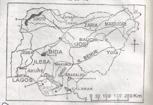
The shaded areas labelled Y on the map are noted for
...
The shaded areas labelled Y on the map are noted for
Dry season wheat cultivation
Floodland rice cultivation
Large-scale fish farming
Large-scale irrigation farming
Correct answer is B
No explanation has been provided for this answer.
Similar Questions
Expressways mainly help intracity traffic in that ...
A feature commonly found in the youthful stage of a river is ...
Urban and rural settlements are best differentiated by their? ...
The correct arrangement of the layers of the earth crust from the surface to the interior is? ...
A manufacturing industry would tend to be market-oriented if the? ...
Which of the following pair is not correct in the development of land and sea breeze? ...
Which of the following is a vegetation characteristics of the Tropical rainforest? ...
Which of the following is a product of chemical weathering? ...
Which of the following is not true of the relationship between the sun and the earth? ...