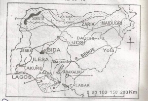
The shaded area labelled Z on the map indicates the part ...

The shaded area labelled Z on the map indicates the part of Nigeria that suffers most from
River blindness
Tse-tse fly infestation
Drought and desertification.
Toxic waste pollution
Correct answer is C
No explanation has been provided for this answer.
Similar Questions
The roots of trees in the mangrove forest in Nigeria are aerial because ...
An example of a non-renewable resources is? ...
The annual range of temperature at Station X is ...
Sandstone can be classified as? ...
Which of the following pairs of cities have both seaport and international airport? ...
Iron deposits are found in economic quantities in? ...
Lateralization of the soil is very common in the? ...
Which of the following is a problem of world transportation? ...
Nigeria's second sea port in terms of tonnage of goods handled is? ...