
31o
41o
51o
61o
71o
Correct answer is D
No explanation has been provided for this answer.
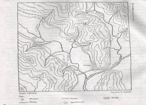
The highest point int he area depicted on the map is just above
900m
800m
700m
600m
500m
Correct answer is B
No explanation has been provided for this answer.

The drainage pattern of the area shown on the map is best described as
Dendritic
Radial
Trellis
Rectangular
Annular
Correct answer is C
No explanation has been provided for this answer.
A profile drawn along M-P east of Parko - Ego road on the map describes a
Ridge
Scarp
Concave slope
Convex slope
Broken ridge
Correct answer is C
No explanation has been provided for this answer.

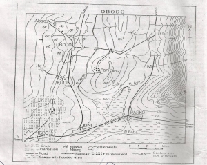
Col
Pass
Road gap
Wind
Spur
Correct answer is A
No explanation has been provided for this answer.
JAMB Subjects
Aptitude Tests