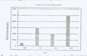
Line graph
Bar graph
Pie Chart
Star graph
Correct answer is B
No explanation has been provided for this answer.

The common modes of transportation in the mapped area are
Railway and water
Pipeline and railway
Road and water
Air and water
Correct answer is C
No explanation has been provided for this answer.

Which of the following statements is true about the drainage of the mapped area?
The watershed from which the rivers take their sources is in the North West
R.Isbo and R.Gembeh are the rivers that drain the distrint
R.Gembeh has many distributaries
An oxbow lake has been formed at the point of intersection of R.Isbo and R.Gembeh
Correct answer is B
No explanation has been provided for this answer.
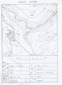
The bearing of Bodel from Bebe is
25.0
255.0
115.0
150.0
Correct answer is B
No explanation has been provided for this answer.

The distance as the crow flies from Bebe to Bodel is
12.75km
10.00km
7.25km
5.25km
Correct answer is B
No explanation has been provided for this answer.
JAMB Subjects
Aptitude Tests