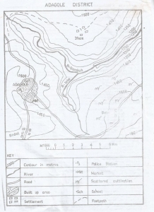
The lowest point in the map is in the
South-east
North-east
South-west
North-west
Correct answer is B
No explanation has been provided for this answer.
The contour interval on the map is
50 metres
100 metres
150 metres
200 metres
Correct answer is A
No explanation has been provided for this answer.

The point where R.Isbo meets R.Gembeh is called
An entrepot
A watershed
A lagoon
A confluence
Correct answer is D
No explanation has been provided for this answer.

The western part of R. Gembeh flows through
A delta
A gorge
A levee
An undulating plain
Correct answer is B
No explanation has been provided for this answer.

North Western part of the map
North Eastern part of the map
South Western part of the map
South Eastern part of the map
Correct answer is D
No explanation has been provided for this answer.
JAMB Subjects
Aptitude Tests