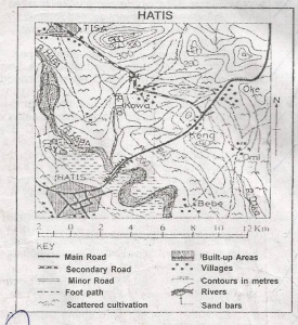
The main occupation of the people in the area on the map is most likely to be
Fishing
Lumbering
Mining
Farming
Correct answer is D
No explanation has been provided for this answer.

The length of the secondary road on the map is approximately
11.5km
12.5km
13.5km
10.5km
Correct answer is C
No explanation has been provided for this answer.

The Oke-Hatis Road passes through the floodable plain of River Haba by means of
A flyover
An embankment
An underground passage
A road cutting
Correct answer is B
No explanation has been provided for this answer.

A common feature of the lakes marked F,G,H is that they are
Used for HEP
Located very close to the equator
Located within the East African Rift Valley
Very shallow
Correct answer is C
No explanation has been provided for this answer.
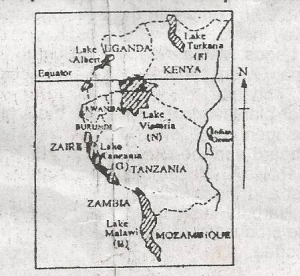
The lake marked N is mostly used for
Transportation and irrigation
Transportation and fishing
Tourism and domestic water supply
Tourism and HEP generation
Correct answer is B
No explanation has been provided for this answer.
JAMB Subjects
Aptitude Tests