
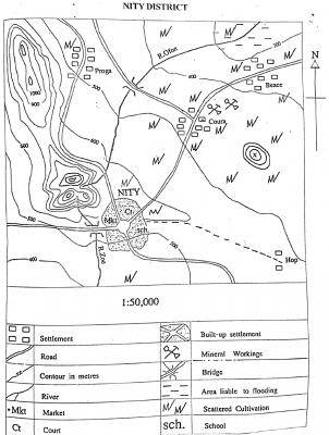
The relief feature on the west of NITY which extends to the north-western corner of the map is a
gorge
plain
plateau
ridge
Correct answer is D
No explanation has been provided for this answer.
1: 25,000
1 : 50,000
1 : 100,000
1 : 150,000
Correct answer is C
No explanation has been provided for this answer.

What is the relief feature marked X?
Ridge
Plateau
Knoll
Gorge
Correct answer is C
No explanation has been provided for this answer.

The highest elevation in the mapped area is approximately
800 m
900 m
1250 m
1400 m
Correct answer is C
No explanation has been provided for this answer.

Which of the following settlements is nodal?
Beace
Hop
Proga
NITY
Correct answer is D
No explanation has been provided for this answer.
WAEC Subjects
Aptitude Tests